
Itinerary 1: The Great Western Pass
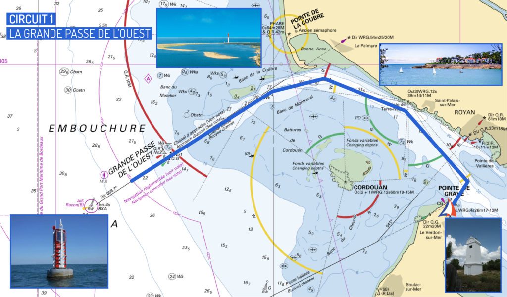
The first navigation circuit on the Gironde estuary that we propose today is the Grande Passe de l’Ouest.
If you are planning a cruise to the North, to go to the Charente channels for example and discover the island of Oleron and the island of Ré, or even further North, sailing through the Breton channels to the island of Yeu, this navigation itinerary is a very good way to prepare yourself.
This pass will lead you to buoy BXA, the northern landing buoy of the Gironde estuary, marking the beginning of the channel. This buoy signals to commercial and cruise ships that they are entering the mouth of the Gironde.
Prepare your navigation to the Great Western Pass
Before casting off, it is important to get information on the swell formation. Indeed, navigation can become uncomfortable when the peak to trough amplitude reaches 1m50. If this is the case, and if this is your first boat or if you are discovering the Gironde estuary, it is advised to be accompanied by an experienced skipper.
In order to prepare this navigation, it will be necessary for you to calculate the time of slack water (the reversal of the current) according to the desired time of return. Indeed, we advise you to plan between two and two and a half hours of descent in classic weather conditions.
From Port-Médoc
For this navigation, leave Port-Médoc and keep your boat inside the main navigation channel (green buoys to port). Indeed, the shoals are shifting and numerous in this part of the Gironde estuary, especially west of the green buoys axis.
Cross the mouth of the Gironde to reach the Charente coast and sail along Royan and Saint Palais-sur-mer, to reach La Palmyre and La Bonne Anse. Indeed, it is preferable to navigate on the Charente-Maritime side when you take the Grande Passe de l’Ouest by boat because the ebb current, the current created by the falling tide, is favorable and the bottoms are healthier there.
The return to Port-Médoc
The return to Port-Médoc, with the help of the sea water, will offer you a breathtaking view of the beaches of the Charente coast and the “cabanes à Carrelet” of the Gironde Estuary, these fishermen’s huts on stilts, heritage of the region. Don’t hesitate to use a tide gauge for this part of the navigation towards the Pointe de Grave and the Saint-Nicolas lighthouse.
The drift will take you naturally to Port-Bloc, then, once your boat is sheltered from the current, you could reach Port-Médoc.
As a reminder, on this route, the points of vigilance are :
- The height of the swell,
- The strength of the current,
- The shallows between the green buoys and the Cordouan plateau,
- The bank of Saint-Georges, towards which your boat may drift with the current, the western end of which is currently less than half a nautical mile east of red buoy number 12.
Itinerary 2: The Southern Pass or Passe de Grave
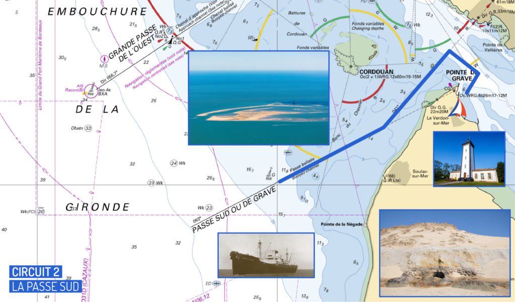
Itinerary 2: The Southern Pass or Passe de Grave
The Passe Sud, or Passe de Grave, although an itinerary reserved for experienced boaters, represents a charming navigation route on the Gironde estuary.
This pass will lead you to buoy G, the southern landing buoy at the mouth of the Gironde. This particularly nice navigation will allow you to discover the coasts and the beaches of Soulac-sur-mer.
From Port-Médoc
When leaving Port-Médoc on board your boat, cross the Pointe de Grave and the Saint Nicolas lighthouse. Make sure to systematically keep the green buoys on your port side. Moreover, once you have passed Port-Bloc, it is important to round off your course so that your boat stays within the channel buoys.
Once past the Pointe de Grave, move away from the shallows at the semaphore beach near the Saint Nicolas banks. You will be able to enjoy this navigation off Soulac while heading to the G landing buoy in complete safety.
To do so, always keep your boat inside the channel, the shallows being particularly present between Soulac and the Amelie beach where they culminate. You will be able to see the wreck of the Hollywood, this American liner which ran aground on November 29th, 1945 on the Médoc coast at the Pointe de la Négade.
When the weather conditions are optimal, and the peak to trough amplitude is less than 1.5 meters, you will reach the blue waters of the Atlantic Ocean, free from the influence of the waters of the Gironde Estuary. An ideal navigation for boaters who love the open sea!
The return to Port-Médoc
The return to Port-Médoc must be done with the help of the current. It will be important once again to calculate the time of slack water (the reversal of the current). First of all, align your boat with the Pointe de Grave. Again, it is very important to respect the green buoys when approaching the banks of Saint Nicolas which are the most delicate part of this itinerary in the South Pass of the Gironde estuary. Once you reach the coast of Verdon-sur-mer, round the point generously to avoid the shoals of Saint-Nicolas in front of the semaphore. At the foot of the Pointe de Grave, the waters are healthy, but make sure you go around the fishermen’s lines in order to respect their working environment.
Depending on the tidal range and the time of the tide, the area around the Pointe de Grave can be more or less tumultuous with sometimes the formation of small pools (water rising from the bottom and bubbling as a result of underwater currents that can upset your boat).
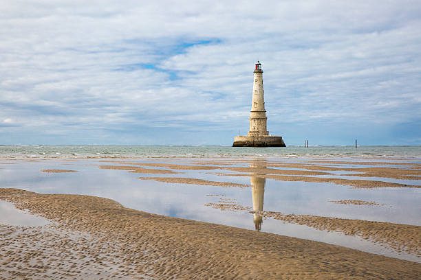
Itinerary 3: The Cordouan Lighthouse
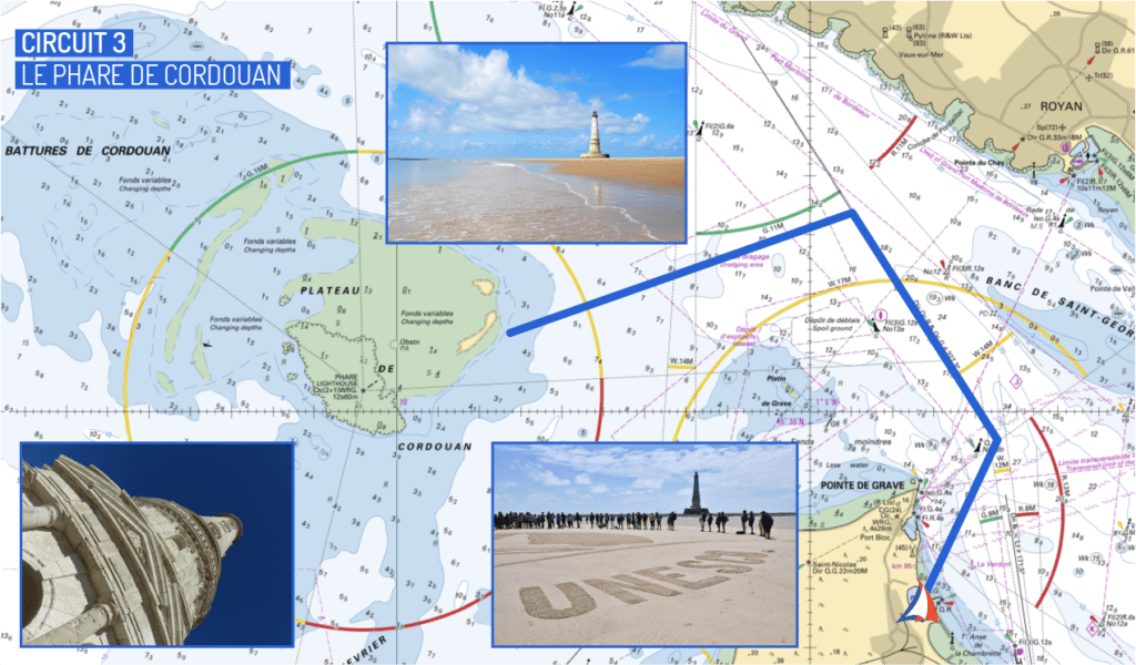
Itinerary 3: The Cordouan Lighthouse
The Cordouan lighthouse is one of the most popular navigations in the Gironde estuary.
Also known as the island with no name, the Cordouan plateau is a sandbank located in the Gironde Estuary not far from Port-Médoc, off the coast of Verdon-sur-mer. Navigation can be tricky because of the variable bottoms, especially when the tidal coefficients are high, favoring the involuntary grounding of boats. On the other hand, when the weather conditions are good, it is one of the most appreciated navigations by the boaters.
Prepare your navigation to the Cordouan lighthouse
In order to optimize your half-day or your day on board your boat, it is important to prepare your approach. To do so, we advise you to leave Port-Médoc about two hours before low tide. Depending on the tidal range, the currents outside the Gironde estuary can be more or less intense. A first current carries you to the southwest and a second current carries you to the west, and these two currents separate on the eastern point of the sandbar of the Cordouan Lighthouse plateau. Depending on the wind strength, you will be able to compensate by drifting your boat more or less.
From Port-Médoc
From Port-Médoc, head for the Pointe de la Coubre, on the other side of the Gironde estuary, towards La Palmyre and La Bonne Anse on the Charente-Maritime side. This course will allow you to go around the Pointe de Grave, and to gradually adjust your course during the navigation.
During spring tides, when the tidal range is lower than average, the currents are powerful on the eastern tip of the Cordouan lighthouse plateau. This place and its sandbanks are in perpetual evolution, and the erosion of the sand results in the existence of variable bottoms.
Anchorage at the Cordouan lighthouse
To make a stopover, a mooring area is at your disposal. Depending on your draught, you are advised to keep a distance of 30 to 40 meters from the shore when anchoring your boat. When you anchor, make sure that your boat is facing the current. If you want to land on the sandbar, a motorized dinghy can be very useful.
Your stopover can last up to two hours after high tide.
Route 4: The Ports of the Right Bank
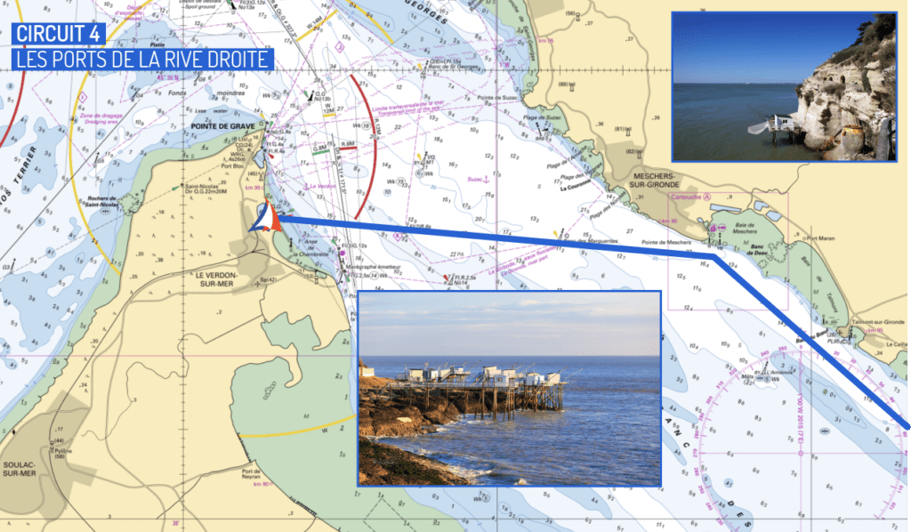
Route 4: The Ports of the Right Bank (part 1)
For this last suggestion of a navigation tour on the Gironde estuary, we suggest you to discover the ports of the right bank.
The Gironde estuary offers a multitude of very pleasant stopovers for those who wish to embark on their boat to discover the Charente coast. Royan is the most famous destination but we can propose you other less frequented but equally pleasant destinations such as Meschers or Mortagne. With this last itinerary, we propose you to discover the harbours of the right bank of the Gironde river from Port-Médoc.
The ports of Meschers and Mortagne are lock ports. These locks open and close automatically, so if you wish to stop over with your boat, it is important to find out about the schedule beforehand. The harbours of Meschers and Mortagne both offer a 50% discount on the port of call for boaters whose home port is in the Gironde estuary, such as Port-Médoc.
The port of Meschers-sur-Gironde
You can continue your navigation on the Gironde estuary towards the port of Meschers. We advise you to arrive during the rising tide. To do so, go along the cliffs of Meschers-sur-Gironde, on the Charente-Maritime side, and contemplate the Carelet huts, these fishermen’s huts on stilts, as well as the Régulus caves, these troglodytic dwellings dug in the cliffs of Merchers.
When approaching the port of Meschers, round off your angle by taking care to place your boat in the center of the access channel to the port leading to the lock. Remember to report your arrival to the harbour master’s office on channel 9 of your VHF. The reception pontoon will be located slightly to port, facing you. When you arrive at the amount to stop for a night in the port, let yourself be tempted by a nice walk to the caves of Regulus.
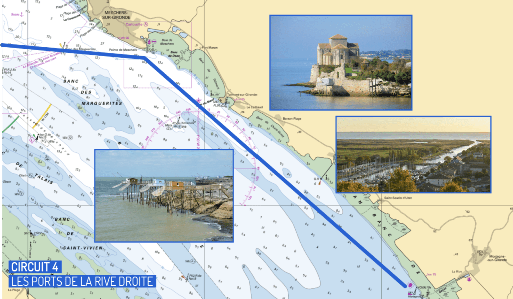
The port of Mortagne-sur-Gironde
For the port of Mortagne, carried by the current, sail along the Charente coast from Meschers-sur-Gironde, passing at the foot of Talmont-sur-Gironde, keeping your boat at a good distance from the mudflats, a natural sedimentation area made up of non-sandy materials. If you are sailing offshore, for example if you come from Port-Médoc, be careful to keep away from the cardinal of the Amiens, the wreck of Talmont whose masts can still be seen during spring tides.
As you approach the port of Mortagne-sur-Gironde, you will find a cardinal buoy that will indicate the presence of a dike extending into the river. In order to respect this cardinal, align your boat carefully with the red buoy because the water will tend to push you to starboard. Then, stay in the center of the access channel, between the reeds, until you reach the harbour lock.
Here are four examples of navigations on the Gironde estuary that will allow you to discover the sights of this magnificent body of water. For longer navigations, it is of course possible to follow the estuary to Bordeaux by following the buoys of the channel of great navigation which will lead you to your destination. The different lock schedules change throughout the year, so don’t hesitate to contact the harbour master’s office of your port of call before starting your cruise through the Gironde estuary from Port-Médoc.
Important reminder
These circuits are given as an indication but they do not replace in any way a navigation manual. Their purpose is to present the range of possibilities in the sailing area. Before any trip, it is essential to check the weather conditions (wind, tide and current) and to make sure that your boat contains the safety equipment required on board a recreational vessel as provided for in Division 240. The complete list can be downloaded from the website of the Ministry of Ecological Transition and Solidarity: www.ecologique-solidaire.gouv.fr.